
Getting to anywhere in Singapore is a breeze. There’s MRT, LRT, taxis, Uber, Grab, etc. The maps and routes in the MRT is pretty much easy to understand, so no problem over there. If you do get into trouble, there’s always an information office in the station. Taxis are always available in most fancy and tourist-y places, and you can order an Uber anywhere.
Buses are a bit different though.
You see the bus information and routes passing a stop, but there’s no map! You can see a lot of stops but which one is near to where you’re going? What time do the buses arrive? What’s the cost? Why isn’t there any announcement like the MRT?
Well don’t you worry my fellow traveller, this guide is here to help you!
I’ve had a few mishaps with the bus (e.g. missed a stop, wrong bus, etc.), but I quite enjoy taking the bus compared to the MRT because most of the time the stops are closer to where I’m going. MRT is of course faster and not that expensive as well, but you’re usually underground (in the city center at least, you’re probably going there right?) and you still have to walk a bit after getting off. On a bus, my favorite thing to do is sit on the back row, open my book, and just read while watching the SG scenery go by. Can’t really do that on the MRT; most of the time you can’t sit, have to walk to the platform, and then wait for the train.
The idea to write this post came when quite a few of my friends don’t prefer taking the bus. Not surprisingly, the reason is they don’t really know how to enjoy the ride because of things like:
- Not knowing when to get off
- Which station is close to Merlion?
- Really depends on traffic
- Why isn’t it here yet?
And so on. Not a lot of reasons, but just enough to avoid it. So I think it’s about time to clear up some myths and disseminate tips on how to ride the Singapore bus like a freakin’ Pro. Enjoy!
Planning Your Route
So you’ve decided to use the bus. I can tell you that most of the time the deciding factor is the route. You know it’s closer using the bus compared to the nearest MRT stop or it’s near-ish but you just don’t want to walk. But how do we know which bus stop to board?
Two words: Google Maps.
Using Google Maps properly is a skill that should be taught to everyone at this day and age. You can get around on your own to anywhere with just an internet connection. So if you’re in Singapore for just a few days, it’s really worth it to get a data package or roaming because you’re really gone use it to travel around.
“What about other travel apps, like GoWhere or MyTransport”, you ask? I’ll get to that later, be patient!
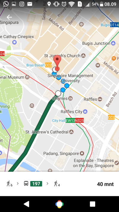
Let’s use an example. I want to go from NUS — specifically the science building where I usually work — to the Singapore Art Museum (awesome museum, I recommend it!). I’d type my in current location and the place I want to go and just tap to the train symbol to get this picture:
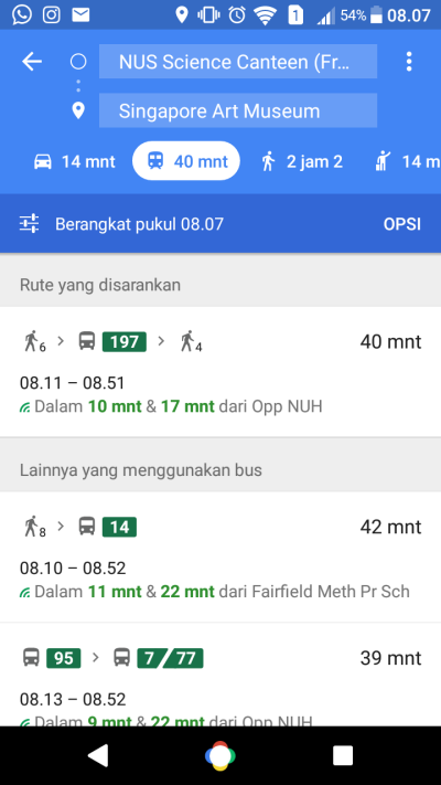
As you can see, the first option is the bus, great start. Couple of things to note here, to get to the bus stop I need walk for six minutes and after getting off I need to walk for four minutes. You can see from the walking guy in the directions. The bus that I will be using is the one numbered 197.
Options (Opsi, just under the different modes of transport) lets you modify whether you’d like a route that’s using only buses, or combination between bus and MRT. You can also pick a route that’s going to make you walk less or the one with less transit. Useful when you want to savor the bus ride by reading all the way to your destination (like me!). Just left to the options, you can also set the time to leave (Berangkat means go) and Google will pick the route that’s the fastest according to the bus schedule. Let’s go with Rute yang disarankan or the recommended route. It’ll take me around 40 minutes to get there, and the 197 bus will arrive in approximately ten minutes from now, with the bus stop name ‘Opp NUH’.
To see the details, I just need to tap that my choice of route and it goes to this next screen:
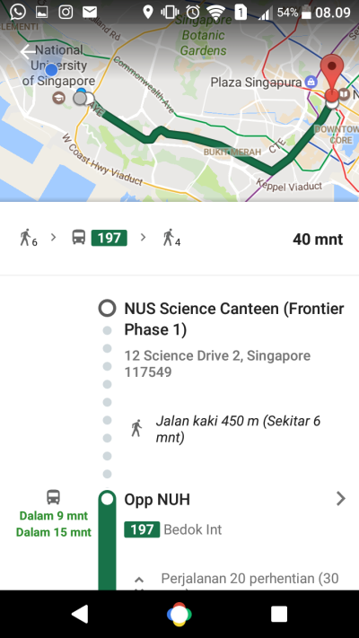
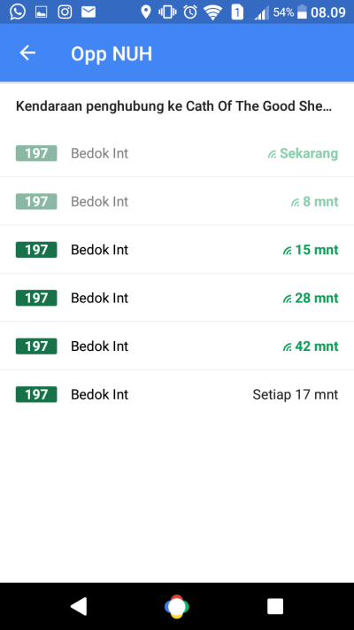
Here you can see your bus route and of course more details like walking for 250m (Jalan kaki 450m) and 20 stops to your destination (Perjalanan 20 perhentian). Say you want to go half an hour later, because you’re stuck with that pesky presentation that you need to finish. Tapping on the bus icon will show timings of the bus arriving on that stop, like this screen:
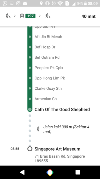
Going back to the previous screen, you can also expand your route so that it shows every bus stop that the bus passes before going to your destination. It’ll make it easier for you not to miss your stop. More details on this later, but you should see something like this:
You’re probably asking, ‘what if I got lost going to the bus stop or to the museum after getting off?’. In that case, you can just slide navigation details down or tap on the mini map and you can zoom in on the route after getting off the bus stop, like this:
Done and done. But wait! This is what you should do before moving anywhere. It’s a warm up. It’s easy. Let’s get to the good stuff.
The Actual Bus Stop
Why is this a step? Well, because most of the time people get confused, lost, and angry at this step. A bit of a hyperbole there, but you get the idea. There’s also some useful things that you might not notice while you’re there. But first, remember this:
In Singapore you drive on the left side of the road.
The cover image is a stock picture so the driver’s position is different. Therefore, make sure you’re going to the right bus stop. If the bus route goes to the right, then you go to the bus stop across the road. Or you just might go the opposite way and get lost for a few days hours. Not the worst thing that could happen, but like you don’t want that right? I’ve had this experience before. Be careful.
Next, there’s one thing that you have to see at the bus stop. It’s the bus services board. All your questions are basically answered in this neat poster-like format. However, most people seem to shrug this off and really not notice it. Which is why I will dissect the board information to you. Sit tight.
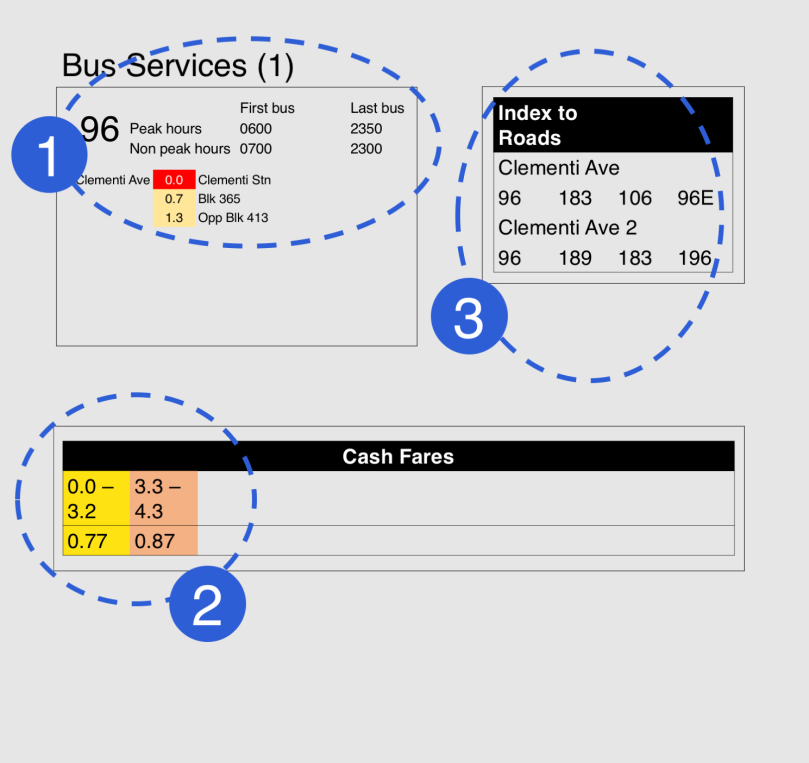
At first, this seems pretty straight forward, but it may trick you when you see it in real life. Some of you. Okay maybe most of you. I’ve said the following facts to my friends a couple of times and everyone is still surprised. So you might be. Not a very good sample but bare with me please.
The Bus Schedule
First and foremost, we take a look at the bus schedule. It’s pretty straight forward. 96 is the number of the bus service and next to it is the frequency (not shown, but you can see it) and first and last bus. If you’ve used Google maps to get to this point, most likely the bus you’re using is operating. You can use this information if you frequently use this route and will need to take bus at dawn or midnight.
What is not straight forward is the numbers and the station location. Aha, you may think this is very normal, but from my perspective—reminiscing the Indonesian public transport system—this is a baffling puzzle. To sum up:
- The first stop is the current stop. The one where you’re standing right now. You can see the road name on the left and the bus stop name on the right
- The bus route follows the line from top to bottom, left to right.
- The numbers in between the road name and the bus stop represent the distance (in km) between current bus stop to bus stop X
- If you want to go a stop named X (say Opp Blk 413), just see the distance (1.3) and you can calculate the fare from the bottom table (2)
- Colors change based on the price of the fare
- If you see a different road name as you go down the route, that means the bus changes to a different road
This is a lot of information. It is condensed in such a way that you can really use it well if you know the tricks. So far, you know how many stops are there to get to your destination (which you can also see in Google Maps) and the fare.
The Fares
Now you know that the colors in the schedule represents the fare. So you don’t have to calculate the fare, just see the color, look at the bottom table, and voila! The fare for cards are cheaper by a bit. They’re not shown, but you can see it online. There’s also fares for concession cards, if you have a child or senior with you. They enjoy a lower rate too.
Index to Roads
At first, I thought this table isn’t really useful. I mean I just need to see my bus and how much does it cost to get there. However, sometimes Google can be misleading. You need to be a bit clever sometimes. It can show you routes that will take longer due to their ‘best route’ algorithm. It’s good, but not the best.
If you want to go the a bus stop at a certain road, you just have to see that road, and see if there’s an alternative bus that passes that stop on that road. Some buses take quite long to get to the stop, so if there’s an alternative to get to where you’re going, just get on a different bus that gets you to the same place. This is especially true for downtown or orchard, there’s a lot of different buses passing through one stop.
Getting On and Off the Bus
At this point you should be at bus stop, figured out which bus you should take and memorized the way to your destination like the back of your hand. You’ll probably waiting for the bus right now. Some bus stops show the time when the buses arrive (e.g. in Lucky Plaza). Most places don’t have that luxury, though. So how do you know when will your bus arrive?
Now you might shout out that you can check the timing from Google maps, and you’re right! However, Google Maps is a battery hoarder on both Android and iOS. I’d like to keep my phone on whenever I go out, so I’d recommend this app called SG BusLeh. It’s a very light app so you can use it on any Android phone (and it doesn’t lag). For iOS users (and they have an Android version too), I’d recommend the official App from Land Transport Authority (LTA) called MyTransport. It has a lot more functionality that you probably need a day to use all of it but just go straight for bus arrival times. This app also gives you notifications if there are any disruptions on the MRT lines. All apps usually have an indicator (a line under the minutes to arrive) that shows how crowded is the bus. Green is not really crowded, red is no seat for you, Mr.
MyTransport actually offers a service where you can have notifications when to get off while taking the bus. Unfortunately, it’s not perfect. I’ve tried it a few times and it doesn’t really work. Google Maps can detect my location too, but again it’s very heavy on the battery as both apps need your location via GPS and mobile data.
My tip on knowing where you are while on the bus: looking at the meter on the bus.
You need to tap in and tap out to take the bus or use cash fares. The tap out meter—if you look closely—shows the fare, the route distance in km, and the name of the stop. This is probably the easiest way to keep track of where you are without your phone running out of juice. Two ways to get this done, the easy way and the fun way.
The Fun Way
Before getting on, write down or remember the distance to get to your destination. If we use the previous example where I need to get to the Singapore Art Museum, the number I remember is 9.4. You can see it on the bus services board.
When you’re inside the bus, look at the meter before it changes at the next bus stop. The meter shows a red ‘don’t tap’ symbol a few minutes after you leave the current stop, and when it’s near the next one it changes to the next stop’s name and distance. You should remember the one that’s your current stop.
In the example, I would have to do 7.6 (distance at current stop) + 9.4 (distance to get to where I want) = 17.0 (what the meter shows when I’m there). If you don’t want to rush and probably miss the stop, I’d recommend also checking the distance of 1 stop before your actual stop. Therefore 7.6 + 9.1 (distance of 1 stop before the one I get off) = 16.7. So your cue should be stay calm until 16.7 shows on the meter, get up, and get off on the next stop. I made a summary here:

BONUS: You can brag about how you remember so many numbers and have to add them in particular way. Awesome. For me at least.
The Easy Way
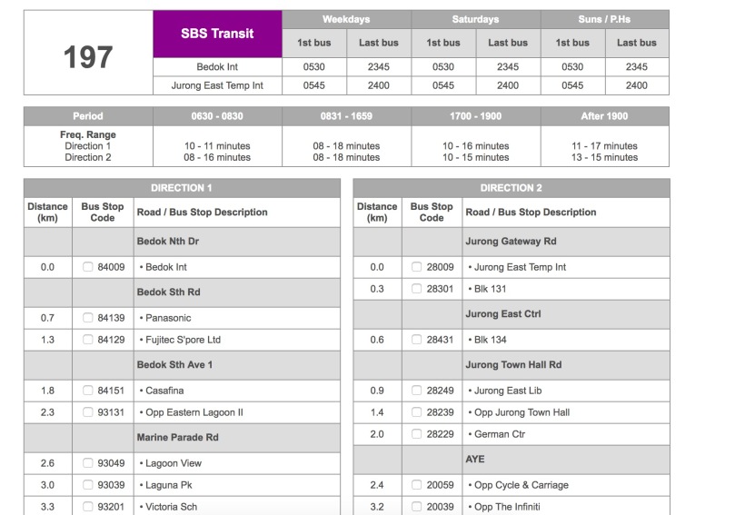
Now, the Easy Way is not much different with the Fun Way, that is you still have to watch the meter to see where you are. However, we’ll use a tool that the LTA provides. Go to this bus guide and just find the bus number that you need to see. Using the last example, you’d land on this page:
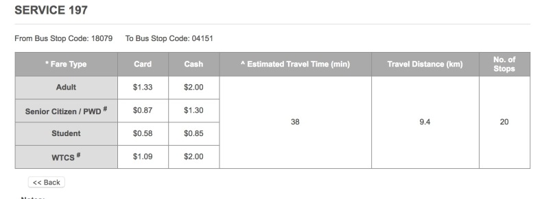
The numbers shown there corresponds to the meter, e.g. not based on the station you’re located. You still have to remember the 16.7 and 17.0, but this way you won’t have to do the additions and the rest. It even has a fare calculator, just tick the 2 stops, and you’ll get to this page:
Now you may ask, ‘Why do I have to do this? Why can’t I just count the number of stops?’. Well, if it’s during the day and there’s a lot of people, you can. However, if nobody presses the ‘stop’ button and nobody wants to get on at a certain bus stop, the bus will skip it. You’ll probably don’t realize it. You’ll be even busy talking to your friends and family to remember the correct number of stops even during the day. So the answer is you can, but I’d say avoid it.
———-Voila! You have been transformed into a Pro Bus Rider!———-
That’s all there is to it. If you’re interested on an actual map of bus routes, unfortunately there isn’t one. Why? Because the routes are so many that you can’t put all of them in a single map. Luckily, there’s a tool at this website that tells you the routes of buses that pass a certain bus stop. Pick one of the stations in downtown or city centers and you’ll get something like this:
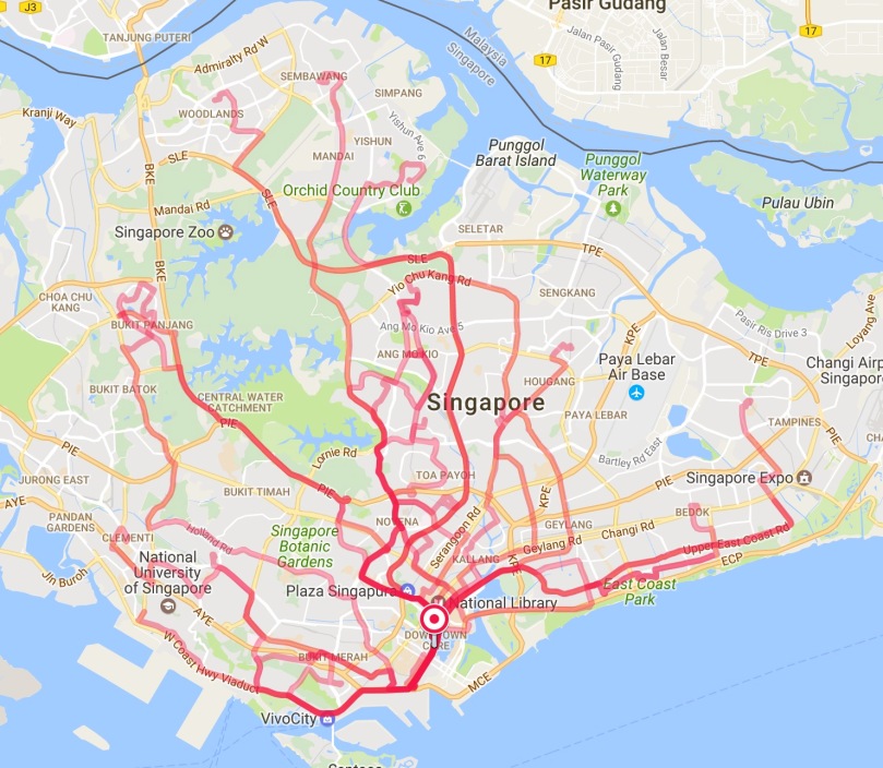
It’s accessible only via a web browser, so you might want to play with this when you’re using a computer. Very useful to where the buses will actually take you in Singapore. You’d be surprised at how easy it is to get around with a little or no transits using the bus.
If still you have any questions, ask away in the comments! Otherwise, enjoy your new adventure skills as a Pro Bus Rider~
PS: If you’re wondering the abbreviations at the bus stops here’s some of the most common you’ll see:
Opp = Opposite (meaning across the road)
Blk = (apartment) Block
Int = Interchange
Aft = After
Bef = Before (not beef)
Sch = School
Stn = Station (usually MRT)
There’s more, but you’ll figure it out eventually.

Still confused at opp, never use bus before
LikeLike
Have you checked Google Maps or any other apps? They should direct you to you destination with great detail.
LikeLike